Given the frailties of human nature -- and the possibility of human error -- it should surprise no one that in an age where sailors have every possible electronic enhancement at their disposal (from shipboard computers to GPS navigation devices), one bad decision can still wreck a ship that is 952 feet long, 116 feet wide, weighs 114,137 gross tons and cost $570 million to build.
 |
| Passengers in lifeboats abandoning the Costa Concordia on the night of January 13, 2012 |
One of the moments that I treasure from Cameron's film is a simple little segment of CGI work. It captures the moment (approximately 12:45 a.m. on April 15, 1912) when the first flare went up from the Titanic. Instead of showing it from the level of the ship's deck, the film shows the flare as just a tiny little puff of pink against a black sea and black sky. Suddenly, the audience realizes how isolated the Titanic was in the Atlantic Ocean.
Of course, that's not really true. As any Titanic historian knows, the SS Californian was only five miles away, blocked by an ice field. But because the Titanic sank in the early days of wireless communication -- and after Cyril Evans (the radio operator on the Leyland Line's 6,223-ton ship) had shut off his wireless set and retired for the night -- the crew of the Californian had no idea what had happened until the following morning. For those unfamiliar with the details of the event, Wikipedia explains that:
"At longitude 50 degrees 07 minutes west and steering a course of due west, a position to the south of the Grand Banks of Newfoundland, Californian encountered a large ice field. Captain Lord spotted it just in time and ordered the helm hard right and the engines full astern. The ship's head swung rapidly to the right but it was too late; she actually entered the loose margins of the ice field. He eventually stopped the ship, surrounded by loose ice and heading northeast. Lord decided to stop the ship and wait until morning to proceed further. Before going down from the bridge, he thought he saw a ship's light away to the eastward but could not be sure it was not just a rising star. He carried on down to the engineers' cabins and met with the chief, whom he told about his plans for stopping. As they were talking, they saw a ship's lights approaching. Lord went to the wireless room to find out if Evans knew of any ships in the area. Evans met him on the way and informed him he did: “Only the Titanic.” Lord instructed Evans to call Titanic and inform her that the Californian was stopped and surrounded by ice.
On deck, Third Officer C.V. Groves also saw the lights of another ship come into view on the horizon off Californian's starboard side, and less than ten miles away. To Groves, she was clearly a large liner as she had multiple decks brightly lit. Fifteen minutes after spotting the vessel, Groves went below to inform Lord. Lord suggested that the ship be contacted by Morse lamp, which was tried, but no reply was seen."
 |
| The SS Californian |
"Titanic's on-duty wireless operator, Jack Phillips, was busy working off a substantial backlog of personal messages with the wireless station at Cape Race, Newfoundland, 800 miles (1,300 km) away, at the time. When Evans sent the message that they were stopped and surrounded by ice, the relative proximity made Californian's signal loud in Phillips' headphones (both radio operators were using spark gap wireless sets whose signals bled across the spectrum and were impossible to tune out). As Evans attempted to transmit his ice message, Phillips was unable to hear a separate, prior message he had been in the process of receiving from Cape Race, and an exasperated Phillips rebuked Evans with: "Shut up, Shut up, I’m working Cape Race." Evans listened for a little while longer, and at 23:30 he turned off the wireless and went to bed. Ten minutes later Titanic hit an iceberg. Ten minutes after that Titanic's lookout spotted a nearby ship. Titanic sent out her first distress call 25 minutes later."
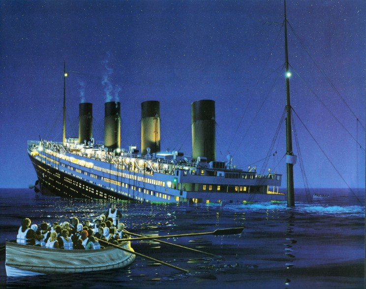 |
| One of Ken Marschall's famous paintings shows the Titanic sinking into the cold waters of the Atlantic Ocean on the night of April 15, 1912 |
Often referred to as "the ship that God himself could not sink," the Titanic disappeared under the waves at 2:20 a.m. A century later, despite our increased knowledge about how solar flares can affect satellite communication, GPS, and other wireless devices, man's overconfidence in technology remains a critical weak point.
On February 9, 2001, the submarine USS Greeneville sank the Japanese fishing boat Ehime Maru in an unfortunate collision which led to the Bush administration’s first foreign relations crisis. Writing to the editor of Salon.com, retired USNR Captain John DeShazo -- an instructor of seamanship and navigation at the United States Naval Academy in the late '70s and early '80s -- asserted that:
“The USNA recruits technocrats to be midshipmen, people fascinated by electromechanical gadgets. They place more faith in electronic sensors than their own eyes. Without an appreciation for the power of human senses, no one learns to focus the attention on the environment in which a seaman's vessel actually exists. Seamanship is not given a high priority in the U.S. Navy. I have personally observed this failing many times. On dark nights, while conducting offshore sail training operations, I used to turn off all the electronics and require midshipmen to steer using the wind on their faces, the stars, and the sea. They nearly always resented this exercise. They would say it was useless and saw no purpose in being deprived of modern electronic devices. They rarely understood their instructor's intentions of honing their ability to focus on details and concentrate on learning to understand the real life existence of their vessel in its environment. Modern American naval officers perceive themselves in the abstract, as if they were controlling their ships over the Internet.”Two fascinating new documentaries that will be screened at the 30th San Francisco International Asian-American Film Festival investigate man's relationship with the Pacific Ocean. Each takes into account the legacy of an island population's tribal ancestors, who learned how to survive and thrive with the help of the ocean.
* * * * * * * * *
Directed by Nā‘ālehu Anthony, Papa Mau: The Wayfinder chronicles a 30-year reawakening among Hawai'ians of an interest in the navigational techniques used by their ancestors to travel back and forth across Polynesia. During the 1970s, a small group of Hawaiians formed the Polynesian Voyaging Society with the goal of building a voyaging canoe in the ancient style. Their dream was to sail the double-hulled Hōkūleʻa using the ocean paths between Hawaiʻi and Tahiti. |
| The Polynesian Voyaging Society's two-hulled sailing canoe |
Although such sea voyages had been described in oral traditions, the voyages had not been made for hundreds of years. As far as they knew, no Polynesian navigators still existed who could teach them an art form that had been passed down through generations of Pacific Islanders.
There was, however, a Micronesian man from the tiny Carolinian island of Satawal who had been invited to Hawai‘i in 1973 by a Peace Corps volunteer named Mike McCoy. Born in 1932, Mau Piailug began his training at an early age by wading in shallow tide pools to gain a feel for the ocean.
He learned about the stars, the winds, and the ocean's currents from his grandfather (Raangipi) and father (Orranipui) and developed an intuitive understanding and deep respect for the sea. By the time he had turned 18, Mau was recognized as a master or "Pwo" navigator in the last ceremony of its kind to take place on Satawal for the next 50 years.
 |
| Mau Piailug initiates Hawai'i's Nainoa Thompson as a Pwo navigator during a ceremony on the Micronesian atoll of Satawal |
Acutely aware that Western cultural attitudes were eroding Micronesia's traditional lifestyles and values, Mau agreed to teach the Hawai'ians how to navigate the ocean without using any instruments in order to pass on his legacy of navigational techniques. Although he agreed to navigate the Hōkūle‘a's maiden voyage to Tahiti, he insisted that there be no compasses, sextants, maps, or any other western-style navigational instruments on board. The journey across the Pacific would be guided simply by his knowledge of the stars and the sea.
Papa Mau: The Wayfinder documents that first voyage as well as Mau's subsequent mentoring of young navigators. It also shows how Mau proved that the ancient canoe voyages throughout Oceania were carefully navigated, and did not just rely on luck.
Mau died of complicated from diabetes on July 12, 2010. On July 24, 2010, members of the Polynesian Voyaging Society gathered at sunrise at Lānaʻi Lookout on Oʻahu, Hawaiʻi (where Mau had taken Nainoa Thompson and others to study the elements of their land). The following emotional video clip ends with a sunset at Nānākuli.
* * * * * * * * *
The ocean may be a formidable opponent, but it is not always a violent one. The Titanic, Ehime Maru, and Costa Concordia were all in relatively calm waters when they met their fate. However, with climate change melting so many of the world's glaciers, rising sea levels pose a threat to island cultures which most people simply cannot imagine.
 |
| An idyllic moment on the coast of Takuu |
Briar March's poignant new documentary, There Once Was An Island: Te Henua e Nnoho, looks at the tiny atoll of Takuu (also known as Mortlock), which is located off Papua New Guinea's east coast of Bougainville. At high tide, the atoll's highest point is about one meter above sea level.
Over the past 1,200 years, the natives of Takuu have built a strong and sustainable culture built around agriculture (especially giant taro) and the fish they get from the sea.
Although Takuu has approximately 400 residents, a 2006 cyclone had a devastating impact on the community which, two years later, watched helplessly as three days of high tides in December 2008 washed away kitchens, personal belongings, and destroyed numerous homes and churches.
 |
| A photograph of the Takuu atoll taken from space by NASA. |
Although many inhabitants are reluctant to leave the only home they have known, the residents of Takuu have slowly realized that their only hope for survival is to let the government relocate them to Papua New Guinea's mainland (where they would live in a land-based culture as opposed to the water-based culture in which they were raised). But what can you do when there is only sporadic government assistance available and few boats stop at your atoll during the year? As Satty (a frustrated father) explains to one of his sons: "You can't climb up a coconut tree and stay there forever!"
Briar March was present in 2008, when two scientists (oceanographer John Hunter and geomorphologist Scott Smithers) visited Takuu to explain the science behind the rising sea levels. March's film contains many poignant moments -- especially the one in which two sisters must say their final farewells as one leaves to return to her home on the mainland while her sister insists on staying behind.
In her director's statement, Ms. March writes:
"We began making the film after seeing an article about Richard Moyle, an anthropologist who has worked on Takuu every other summer for the last 16 plus years. He mentioned that the atoll appeared to be suffering the first impacts of climate change including salty gardens and coastal erosion. Richard was able to give us permission to make a film about the issue on behalf of the Ariki (chief) of the atoll. This documentary is extremely topical and discusses an issue of global importance. It is also a character-driven story told in an observational cinematic style (in contrast to other more science driven, or journalistic films on the subject).
Takuu’s plight draws attention to the situation of other people in the Pacific and in coastal areas elsewhere who will soon face similar problems. In addition to being an important record for all Pacific peoples, this film will help preserve the way of life and cultural identity of a unique Polynesian culture. The Takuu community has stressed to us that they feel they do not have a voice. We hope that, through this film, we will be able to give them one."
No comments:
Post a Comment